Si informano i gentili utenti che, al momento, la vendita dei prodotti IGM è sospesa.
Il servizio di vendita diretta su questa piattaforma è in fase di implementazione e sarà reso disponibile prossimamente. Ci scusiamo per il temporaneo disagio.
Access is free for everyone: private users, professionals, companies and public bodies.
In particular, to those interested in geographic data.
Description
The Italian Military Geographic Institute distributes DBSN data according to the specifications of the National “Catalogue”. In order to comply with European and National directives, the DBSN is also distributed, through network services, according to the INSPIRE/High-Value Datasets specifications. Only themes related to IGMI data have been published.
Data structure has been simplified compared to the official specifications, to make the service effectively usable. This simplification follows the revision of the INSPIRE Directive, which started in 2026.
How to
Access to data is not immediate and GIS software is required (Open source or commercial), to be able to connect to the data and use them.
What you need
You don’t need to register on the website. Downloading is free of charge. GIS software (Example QGis) is required to consult the WMTS and WFS services.
The State land border line and geographic names of Italy are available through download and Web services. Details are in the relevant metadata sheets.
What you get
Access to IGMI data, according to INSPIRE and High-Value Dataset specifications.
How much does the service cost
The service is free, according to the specified user licenses.
Timelines and deadlines
Last update of the database: December 2023. No deadline is currently expected
Go to the service
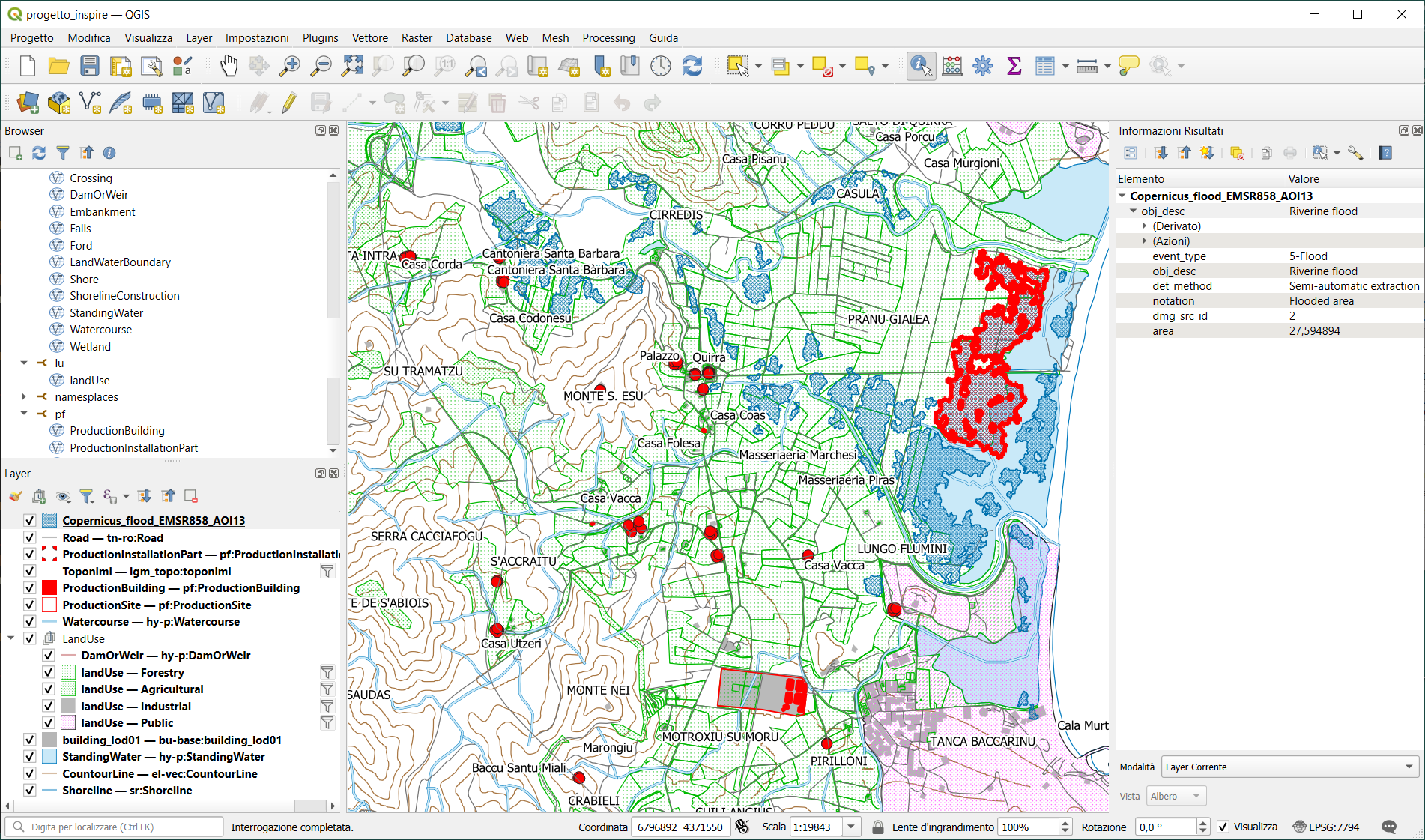
Access to the data is possible through the WFS service. To make the services actually usable, the data structure has been simplified, according to the official INSPIRE specifications.
The theme of Geographic Names has also been created in “Full Compliant” mode with European specifications.
Below are the addresses for access to the services:
Annex I: AU – Administrative Units: https://igmi.esercito.difesa.it/porta-magna/wfs/au
IGMI is not responsible for any kind of direct, indirect, or incidental damage resulting from the use of the information collected through the service described above.
Verto on Line is a software that carries out coordinates conversion, for free and in real time, between the most adopted reference systems in Italy: Roma 40, ED50 and ETRS89, this one in its two realizations, namely ETRF89 and ETRF 2000.
The DBSN (Database di Sintesi Nazionale – National Synthesis Database) is a geographic database containing the most significant spatial information to carry out thematic analysis and representations at national level.
The Web Map Tile Service (WMTS) is an open standard developed by the Open Geospatial Consortium (OGC) for the creation of geo-referenced “tile maps” sharing web services.
The Web Feature Service (WFS) is an open standard developed by the Open Geospatial Consotium (OGC) aimed at building web services for sharing geographic objects.
Pegaso VRS Now is a network of GNSS permanent stations, built by Trimble and certified by the Italian Military Geographic Institute, that provides immediate access to real-time NRTK corrections throughout Italy.
The Open Data Directive, introduced the “high-value” datasets. Their use can be associated with “important benefits for society, environment and economy”.