icona-ricerca_bg
icona-accedi-registrati_bg

Area riservata/Registrati

icona-lingua-ITA

It

Si informano i gentili utenti che, al momento, l’acquisto dei prodotti IGM è effettuabile esclusivamente tramite il sito ufficiale www.igmi.org
Il servizio di vendita diretta su questa piattaforma è in fase di implementazione e sarà reso disponibile prossimamente. Ci scusiamo per il temporaneo disagio.

Database di Sintesi Nazionale (National Synthesis Database)

Who is this service for

Access to the service is free to anyone: citizens, professionals, companies and public bodies.

Description

The DBSN (Database di Sintesi Nazionale – National Synthesis DataBase) is a geographic database containing the most significant spatial information to carry out thematic analysis and representations at national level.

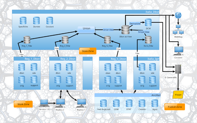
In order to realize the DBSN, with the aim of processing increasingly complete and up-to-date data, regional geotopographic data were mainly used as the primary source of information. At the early stage of the project, the latest updated data were collected and their structure was transformed to make them homogeneous at the national level, while maintaining the original level of detail. Subsequently, data were integrated with data from national public bodies, e.g., cadastral maps from the Internal Revenue Agency, data from Istat, data from other ministries, also considering other information available on the web such as Open Street Map (OSM) data. Where derived information was lacking, data were acquired directly from orthoimages. Specifically in reworking the content, the road system was updated at least for major links; administrative boundaries were derived from cadastral boundaries and a process to match municipal areas with each other and with the state boundaries was carried out; the built-up area were classified according to main use categories. Moreover, for toponymy, an updating and normalization activity has been initiated and is still ongoing. The DBSN is continuously updated by acquiring and integrating new data all the time.

COVERAGE (last updated June 27, 2025)

All the provinces of Italy are published including the area near the State Border, verified by the Geodetic Department with an update to June 2025, which had been excluded from previous publications.

DBSN coverage: in blue are the published areas, in green are the areas published with the latest update

How to

You do not need to be registered with the website to download the DBSN database.

Click on the link in the “Access the Service” section.

The download links will be presented on the screen. The regions, for convenience, have been divided into provinces.

Make the download

What you need

It is not necessary to register with the site. Downloading is free of charge

What you get

The download service, allows the DBSN data to be downloaded in the form of geodatabase files (GDB extension) by province. The data occupy slightly more space than the provincial border to enable even those objects that cross the administrative border to be correctly identified.

The files are provided in zip format, so they must first be unzipped in order to access the contents.

Example of a downloaded file:
File contents after extraction process. The GDB file is highlighted.

A geodatabase file is a folder (directory) containing binary files capable of storing spatial and nonspatial data. The file can be read and viewed by GIS Desktop software. Take care to connect the entire folder and not its single files to the software (e.g., copy the file province.gdb to a local folder on the PC. After that, by means of the GIS software used, connect to the local folder, inside which the file province.gdb will be recognized as a geodatabase. It will then be possible to load the existing classes).

Visualization via GIS software of the geodatabase file, although modifiable in the default symbology, can be considered “rough.” If interested in visualizing the data with a cartographic dressing, we recommend the purchase of the 25DBSN Automatic series raster map product, which is the map at scale 1:25,000 derived from DBSN data by IGMI through procedures of automatic cartographic generalization and application of the defined symbology.

How much does the service cost

The service is free of charge

Timelines and deadlines

Last database update: JUNE 27, 2025 The service is not scheduled to expire.

Access the service

Specifications

The Database structure is based on technical specifications aligned with those established by national regulations (Decree November 10, 2011). The term “sintesi” (synthesis) refers to the selection of information and the simplification of the database structure: the content specifications of the DBSN are a sub-set of the “Catalogue of Spatial Data – Content Specifications for Geotopographic Databases,” which resulted in the reduction from 159 to 91 classes distributed in 10 layers (74 of which are releasable as the remaining ones have not been verified).


In the specifications, the META_IST attibute was introduced for all classes with a list of predefined domains representing an operational metadata indicating the source for each object entered.
The specifications are currently being revised in alignment with INSPIRE guidelines.

Regulations

  • “Catalogue of Spatial Data – Content Specifications for Geotopographical Databases,” annex to Ministerial Decree November 10, 2011, “Technical Rules for defining the Content Specifications for Geotopographic Databases” (Official Journal N° 48, 02/27/2012 – Ordinary Supplement N° 37).
  • Legislative Decree N° 36, January 24, 2006, as amended, on open data and reuse of public sector information.

Terms and Conditions

The database called DBSN (Database di Sintesi Nazionale – Database of National Synthesis) is made available under the Open Data Commons Open Database License (ODbL) ver. 1.0 https://opendatacommons.org/licenses/odbl/1-0/.

IGMI is not responsible for any kind of direct, indirect, or incidental damage resulting from the use of the information contained in the database.

All services