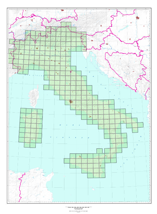
100V and 100L SERIES (M691) “Carta Topografica d’Italia” “Topographic Map of Italy” at scale 1:100,000 “IL FOGLIO”
TYPE
Topographic map derived from surveys at scale 1:25,000. Available in 2 versions:
100V Series published in 5 colors or 7 colors (only some sheets);
100L Series in 3 colors with administrative borders and municipal offices in purple.
CHARACTERISTICS
The information content consists of roads, anthropic settlements, technological networks, vegetation, hydrography, orography. Orography is indicated by shading, contour lines (50 m. intervals) and elevation points. State and Province borders are indicated, inhabited centers are planimetrically detailed; inhabited centers are summarized in the plan.
SCALE
1:100,000
SIZE
30° in Longitude by 20° in Latitude. Average surface area 1500 sq. km.
NUMBER OF ELEMENTS
The Series consists of 278 elements, all of which are available
END OF SERIES
Production and upgrades ended in 1990
CUT
Geographic, referring to the Rome 40 Geodetic Reference System. (Some sheets, produced before the introduction of the Roma 40 System, are based on Bessel ellipsoid oriented to Genoa)
ELLIPSOID
International, oriented to ROME-Monte Mario (1940) (formerly Bessel ellipsoid oriented to Genoa)
PROJECTION
Gauss-Boaga Conformal projection (Transverse Mercator) 6° zones coordinate reduction coefficient of 0.9996 (Sanson-Flamsteed natural projection for sheets produced before the introduction of the Gauss Boaga conformal projection)
KM GRID
UTM, based on ED 50 European Geodetic Reference System
Explore the Italian Military Geographic Institute’s aerial photo archives: more than 300,000 photograms of Italy and some foreign states, taken between 1927 and 2010.
Cartography
Discover the official cartography of Italy produced by IGMI: accurate and updated maps, all realized with state-of-the-art technologies.
Historical Maps
Discover a unique collection of historical maps, perfect for scholars, collectors and enthusiasts.
Terrestrial Photos
Thousands of historic, panoramic and terrestrial images of Italy and overseas territories, taken between 1876 and 1945
Geodetic Elements and Conversion Software
On line purchasing of high quality IGMI products.
Books and Magazines
Increase your knowledge of the territory by the Italian Military Geographic Institute’s publications.
 Contattaci

