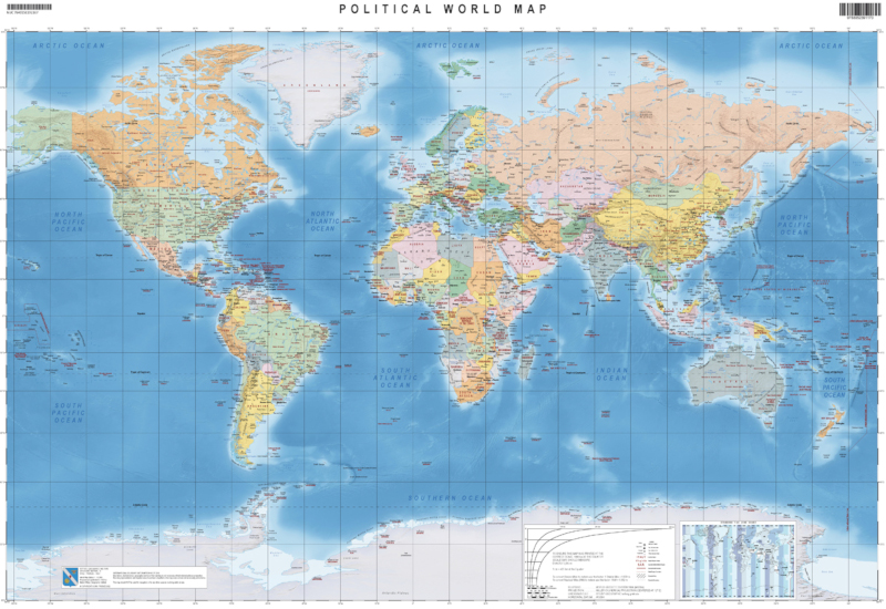
The “Carta del Mondo” – “Political World Map” was produced using public geographic data in English. In the political version are depicted world nations, with graduated colors that, placed in transparency, show the underlying shaded reliefs. The map shows International borders and major disputed areas, capitals, main cities, and named places of major sea and land regions, all related to the average scale of the map.
AVERAGE SCALE AT THE EQUATOR
1:42,000,000
PRINT FORMAT
The map has the print size of 100 cm. x 70 cm.
NUMBER OF ELEMENTS
1 (polical version) – Edition 1 – IGMI
YEAR OF PRODUCTION
2022
CUT
Geographic (between 85° South and 85° North)
PROJECTION
Miller Cylindrical projection and central meridian at 12° (between 85° South and 85° North)
REFERENCE SYSTEM
GEODETIC/ ELLIPSOID
WGS84 (WGS84 Ellipsoid)
DIGITAL PRINT FORMAT
TIF/PDF with 600dpi resolution in four-color process (CMYK)
REDUCED RESOLUTION FORMAT
JPEG with 92dpi (RGB) 857 pixel x 600 pixel resolution
Explore the Italian Military Geographic Institute’s aerial photo archives: more than 300,000 photograms of Italy and some foreign states, taken between 1927 and 2010.
Cartography
Discover the official cartography of Italy produced by IGMI: accurate and updated maps, all realized with state-of-the-art technologies.
Historical Maps
Discover a unique collection of historical maps, perfect for scholars, collectors and enthusiasts.
Terrestrial Photos
Thousands of historic, panoramic and terrestrial images of Italy and overseas territories, taken between 1876 and 1945
Geodetic Elements and Conversion Software
On line purchasing of high quality IGMI products.
Books and Magazines
Increase your knowledge of the territory by the Italian Military Geographic Institute’s publications.
 Contattaci

