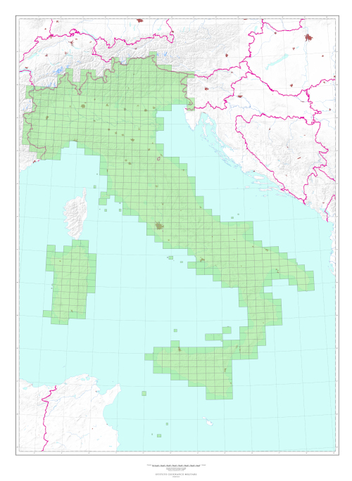
50 and 50L SERIES (M792) “Carta Topografica d’Italia” “Topographic Map of Italy” at scale 1:50,000 “IL FOGLIO”
TYPE
Sheets of the 50 Series are derived from surveys at scale 1:25,000. It is published in two Series:
50 Series Normal
50 Series Administrative Borders Orography is represented only by contour lines, there is no information related to vegetation and administrative borders (State, Region, Province and Municipality) are overprinted in purple. Capitals of administrative areas are also highlighted.
CHARACTERISTICS
The information content consists of roads, anthropic settlements, technological networks, vegetation, hydrography, orography, administrative borders of State, Region, Province and Municipality. Orography is expressed by contour lines (contour intervals of 25 m), elevation points and shading. Inhabited places are planimetrically detailed; the road network is classified according to the nature of the road surface and the width of the roadway. Trees are represented in black on a green background.
SCALE
1:50.000
SIZE
20° in Longitude by 12° in Latitude Average surface area of 600 sq. km. in the ED50 Geodetic Reference System (International ellipsoid with European mean orientation)
NUMBER OF ELEMENTS
632 sheets; all available
PROJECTION
The map is defined geometrically according to the rules set by the Universal Transverse Mercator Conformal Representation (UTM) in time zones 32, 33 and 34
KM GRID
UTM, based on ED 50 European Geodetic Reference System
Explore the Italian Military Geographic Institute’s aerial photo archives: more than 300,000 photograms of Italy and some foreign states, taken between 1927 and 2010.
Cartography
Discover the official cartography of Italy produced by IGMI: accurate and updated maps, all realized with state-of-the-art technologies.
Historical Maps
Discover a unique collection of historical maps, perfect for scholars, collectors and enthusiasts.
Terrestrial Photos
Thousands of historical images both panoramic and terrestrial taken between 1876 and 1945 in Italy and overseas territories.
Geodetic Elements and Conversion Software
Buy on line the technical quality of IGMI, a leading provider of geodesy services in Italy.
Books and Magazines
Learn more about the territory through publications of the Italian Military Geographic Institute.
 Contattaci

