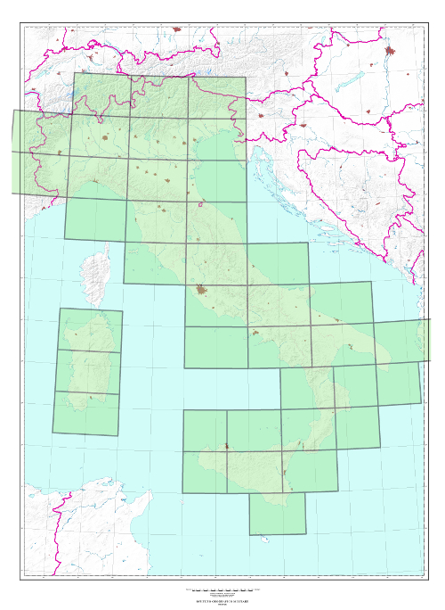
250/G and 250DB SERIES (JOG/G, 1501) “IL MONDO” “THE WORLD” NTERNATIONAL MAP 1:250,000 “IL FOGLIO”
TYPE
Chorographic map derived from larger-scale maps. Available in 6 or more colors.
CHARACTERISTICS
The information content consists of roads, anthropic settlements, technological networks, vegetation, hydrography, orography. Orography is represented by contour lines with contour intervals of 100 meters, elevation points and shading. State and Region borders are indicated; populated places are indicated in pink with perimeter and crossings. The road network is classified according to the importance and nature of the road surface, distances are indicated in kilometers.
SCALE
1:250.000
SIZE
2° in Longitude (north of 40° N) by 1° in Latitude; 1° 30′ in Longitude (South of 40° N) by 1° in Latitude
NUMBER OF ELEMENTS
The Series consists, for the Italian part, of 39 elements, all available
END OF SERIES
Edition n° 4 is in progress
CUT
250/G Series: Geographic, based on ED50 Geodetic Reference System 250DB Series Geographic, based on ETRS89 Geodetic Reference System
ELLIPSOID
250/G Series: International 250DB Series: GRS80
PROJECTION
Transverse Mercator 6° zones Coordinate reduction coefficient of 0.9996
Explore the archive of aerial photos of the Military Geographic Institute: over 300,000 photograms of the national territory and some foreign countries, taken between 1927 and 2010.
Cartography
Discover the official cartography of Italy produced by IGMI: accurate, up-to-date maps made with cutting-edge technologies.
Historical Maps
Discover a unique heritage of historical maps, perfect for scholars, collectors and enthusiasts.
Terrestrial Photos
Thousands of historical, panoramic and terrestrial photos, taken between 1876 and 1945 in Italy and in the overseas territories.
Geodetic Elements and Conversion Software
Buy online high-quality products realized by IGMI, a reference point for geodesy in Italy.
Books and Magazines
Learn more about the territory with the Italian Military Geographic Institute’s publications.
 Contattaci

