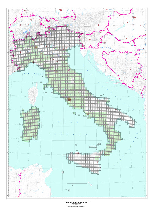
25 and 25DB SERIES “Topographic Map of Italy” at scale 1:25,000 “LA SEZIONE”
TYPE
The Sections of the 25 Series are made by digital or analytical stereo-restitution and subsequently automatically or manually drawn. The Sections of the 25 DB Series are obtained by digital stereo-restitution or from regional numerical technical cartography derivation. Both Series are printed in 4 colours.
CHARACTERISTICS
The Topographic Map of Italy at scale of 1:25,000 consists of Sections of two different Series: The 25 Series, for Sections published until the end of the 90s, and the 25DB Series, for those published later. Roads, anthropic settlements, technological networks, vegetation, hydrography, orography are indicated. Orography is indicated by contour lines (25 m. intervals) and shading. State, Regional, Provincial and Municipal administrative borders are indicated. The road network is classified according to the nature of the road surface and the width of the roadway. Woods: trees indicated in black on a green background.
SCALE
1:25.000
SIZE
10° in Longitude by 6° in Latitude. Average surface area 150 sq. km.
NUMBER OF ELEMENTS
The Series consists of 2,298 Sections; 1140 available, of which about 300 belong to the 25DB Series.
END OF SERIES
Production ended in 2014.
CUT
Geographic referring to the ED 50 Geodetic Reference System.
ELLIPSOID
25 Series: the Geodetic Reference System is the International ellipsoid with European mean orientation.
25DB Series: the Geodetic Reference System is ETRS89 (GRS80 ellipsoid).
Explore the archive of aerial photos of the Military Geographic Institute: over 300,000 photograms of the national territory and some foreign countries, taken between 1927 and 2010.
Cartography
Discover the official cartography of Italy produced by IGMI: accurate, up-to-date maps made with cutting-edge technologies.
Historical Maps
Discover a unique collection of historical maps, perfect for scholars, collectors and enthusiasts.
Terrestrial Photos
Thousands of historical, panoramic and terrestrial images of Italy and overseas territories, taken between 1876 and 1945.
Geodetic Elements and Conversion Software
Online purchasing of high-quality products realized by IGMI, a reference point for geodesy in Italy.
Books and Magazines
Learn more about the territory with the Italian Military Geographic Institute’s publications.
 Contattaci

